Interconnections between time, place and space
Firstly I would like to thank Vicki and Trudy for inviting me to participate in ADA Mesh Cities. It has been a really wonderful symposium and I have loved seeing all the interesting projects over the last few days as well as meeting some fantastic people. Secondly, I would like to thank Edward Bennett, the historian from K Road for collaborating with me on my project Finding the Ghosts of K Road. Edward has generously shared his knowledge and time, even acting as the tour guide (for those who couldn’t make the walk on Friday). I would also like to take this chance to thank my partner Marty – who is my constant collaborator, editor and critic.

A bit of background
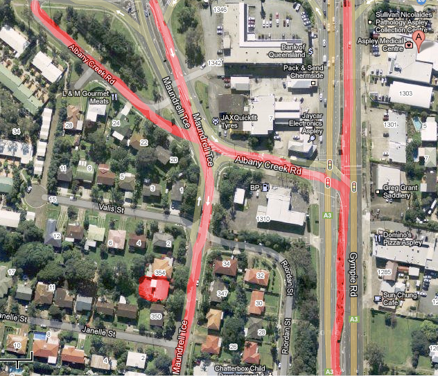
Over the years, I have explored the landscape and maps as ways of articulating identity and memory: personal, cultural and historical. To provide some context, in the mid-1990s I created a performance piece Scalpland which explored the changing landscape of Aspley, the Brisbane suburb where I spent my early childhood years.

Scalpland focused on ideas of colonialism and the gaze – connecting issues of land with the gendered body.

Although this is a very old work, it underlines many of the concerns that still resonate through my practice today.
This ‘poetic performance’ involved me clippering my hair off, using my head as a metaphor for land development and as a way of challenging feminine stereotypes of beauty and conformity by using the pseudo science of phrenology to highlight the perpetuation of assumptions derived from physical appearances. It was also a means to address a singular notion of history, one that was written onto the land by ‘clearing the surface’ and erasing the stories and histories that had gone before. Essentially this work was a response to the changes I witnessed returning to Brisbane after ten years away and the sense of loss I experienced.
Last year when I participated in the SCANZ Residency in Taranaki, I pondered this work again, looking more closely at the suburbs history through old photographs and maps – see Revisiting Scalpland.
While refreshing my research of the area, I discovered that only 100 metres away from my house, where the creek used to be (now buried under a four lane intersection): was an ancient meeting place for the First peoples of this area.
Conceptual focus
One of the concepts that drives my work is creating an understanding of a place. For a long time I have only focused on places that I knew ‘first-hand’, places that had stories that connected me to the site, parts of my personal history as someone who has led a relatively itinerant life. Many of these works were seen as a way of creating a clear line of site (sic) between the landscape and my history and memory. It was also a way of respecting those places – as I felt that though my experience I had a connection and a ‘right to speak’ through a grounded experience of place.
Then I discovered Augmented Reality. I had already been spending a lot of time exploring Google Maps and Google Street view as my partner and love to travel and I always research our destinations. I could see the potential for creating works that explored the idea of being an absent tourist by combining images grabbed from Street View with historical images of places I have never been.
I was becoming a ‘remote’ tourist, discovering locations from afar and building a knowledge of a place, which may or may not have any truth ‘on the ground’.
So taking this concept of being a remote tourist, I developed my first ‘remote’ walking tour, for the Dunedin ADA Mesh Cities, titled Walks of Absent Memory.

This project sort of ran like a ‘set and forget’. I made a blog, created a map and just hoped that the walk would work on a technical level. You see the technology I use “Aurasma” is designed for working with signage and print images, not buildings.
Which brings me to K Road and more recent AR work.

To connect back to my discovery about Aboriginal walking tracks, I was looking at Auckland history and heritage online and came across this image and a story about K Road being the oldest road in Auckland and a Māori walking trail. I was intrigued.

Through reading about Auckland online, I discovered this was a street which had many layers through time. I was fascinated. So I put forward a proposal to create a similar work to the Dunedin project, but offering to guide the walk in person. I titled the work Finding the Ghost of K Road as I wanted to reveal some of the layers of the past.
Then Trudy contacted me, sharing some of her family history and informing me that K Road had its own historian, Edward Bennett. I watched a YouTube clip that Trudy shared and then decided to contact Edward.

It was at this point that this project started to take shape in a different way to my earlier project in Dunedin as I had met a guide, someone who knew this landscape intimately, having extensive knowledge of these multiple histories. As the project developed Edward patiently would correct me if my map points were wrong, if I was facing the wrong way in Street view, highlighting additional places of interest on the way though. It was a conversation that enriched my understanding and gave the opportunity for the walk to be quite a different event to what I first imagined. A walk, guided by an expert, augmented by the technology and imagery of the old buildings.
So, why walking?
Over the years the role of the audience has become more important to my work, as my goal is for people to experience and interact with the work. Even with Scalpland I was looking for a reaction from the audience, and in the text of this work I speak about the gaze as a form of colonisation, implicating the audience.
By engaging people in the physical activity of walking, the artwork can be about the process, about the moment and the shared communication that evolves. I see my map, blog and AR imagery of a place as ways of augmenting the landscape, to provide an opportunity for the walkers to consider the ground and the layers of events that lay beneath their feet. Everyone experiences this ground in different ways, whether as local, tourist or culture/knowledge broker.
My next AR walk will be focused on Amager Island, an old region of Copenhagen. It will be presented as part of Cultura 21 Eco Camp. I think it will be a great adventure, even if I don’t leave my studio. 🙂
Thanks for having me.

Leave a comment