
Walking Backwards into the Future
Augmented Reality in Copenhagen, by Tracey Benson
This article documents the waypoints of the tour of Dragør titled Walking Backwards into the Future being presented as part of Cultura21 Eco Island, Dragør, Denmark.
Related posts
- The Walking Backwards into the Future: Cultura21 Eco Island, Dragør, Denmark proposal details the project goals and the context.
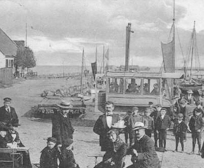
- You can also see the historic images in this article about the tour.
You don’t have to be in Dragør to experience this work. You can also use the app with the landmark building images in this blog post.
There is a printable version of the map for Walking Backwards into the Future.
Technical specifications
Walking Backwards into the Future uses augmented reality, and to view it you must have an internet enabled mobile device running iOS
or Android (tablet or smartphone). You must also have the “Aurasma” app installed.
To install Aurasma:
- Search for and download the “Aurasma” app in Google Play or the Apple App Store.
- Launch the app, click on the “A” symbol at the bottom of the screen.
- In the search box, type in “bytetime” and click “Search”. Select the channel titled “bytetime” then click “Follow” to follow the channel.
Now you are ready to view the work. When you are in front of one of the building landmarks documented in the Walking Backwards into the Future map or this blog post, click the target icon (bottom centre of the screen) and hold your device in front of the frame to watch it animate. Any time you want to view the work in future, simply launch Aurasma, and it will be ready to go.
Note: make sure you are connected to the Internet before holding your device up to the building ‘clues’ from this blog.
Here is your stop-by-stop guide to Walking Backwards into the Future, have fun!
Start of Walk: Dragør Fort

Dragør Fort is situated on a small artificial island with the land bridge from Dragor city. Dragor Fort was built in the period 1910-1915. The fort’s mission was to help deter hostile bombardment of Copenhagen and protect the Drogden channel. The fort area is 32,000 m² of which 2,500 m² are developed.
During the building of the Oresund Bridge (1995-2000) was Dragør Fort used to control vessel traffic in the area via VTS Drogden (Vessel Traffic Service Drogden).
Dragor Fort is now privately owned and used as a restaurant, team building / events, but there is free access to parts of the area. Dragør Fort has a large stock of escargots, which is protected.
Point 1: Blegerstræde

Blegerstræde is a street in the old section of Dragør. Several families who lived on this street made a living out of bleaching fabrics (the ‘blege’ in Blegerstræde means ‘bleach’). Many of the high-end stores in Copenhagen use to have their fabrics such as tablecloths and beddings bleached here. In the beginning of the 20th century the department store Magasin alone shipped 6000 rolls of fabrics to Dragør every year to be bleached in the sun. Each roll was approximately 40m long. The bleaching would take 2 month. The house number 12 is a typical bleaching house. It’s built high to leave room for the tall barrel which was used to cook the fabrics before bleaching. After cooking the fabrics would be rinsed in the sea before they were laid out to be dried in the sun.
Point 2: Mølsteds Museum
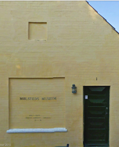
Christian Mølsteds (1862-1930) was a famous Danish painter who primarily painted ships and sea battles. Mølsted’s Museum has several of his dramatic paintings on display. Particularly impressive are his paintings of historical battles as seen and painted from Dragør. The museum is open from May 1st until August 31st.
Point 3: Jens Eyberts Square (Jens Eyberts Plads)
In the Jens Eyberts Square is the house number 6 which was one the home of the skipper Jens Eyberts (1756-1811). The home is very typical for the building style during the 18th century. The attic on the timber-framed house has a hatch and hoist. The entire living room from Jens Eyberts house has been transferred to the Dragør Museum.
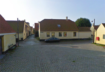
Point 4: Badstuevælen

Badstuevælen is the largest square in the old part of the town. It is not very big, but it is a charming square. The houses number 8 and 12 were built by the architect Johan Hendrich Jørgensen Blichmann in 1790.
Point 5: Dragør Kirke

Dragør Church is a fine small town church which was constructed in 1885.
Point 6: Stationsvej
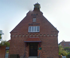
The old railway station at Dragør from 1938. The railway was called “Amagerbanen” and inaugurated 1907. The railroad went from outer Copenhagen “Amagerbro” to Dargør. The Route was 12 km long and was closed in 1957.
Point 7: Jan Timanns Plads

Jan Thimanns Square was named on the King’s supreme authority after the bailiff Jan Pedersen Timann (1683-1749). Timann lived on one of the very first farms in town.
Point 8: Dragør Strandhotel
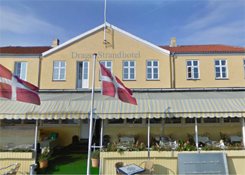
The Dragør Beach Hotel (Strandhotel) is a hotel near the coast. The present buildings date back to 1845, however there were substantial renovations done in 1930. The hotel is on the site of the former herring market from the Middle Ages. The market was covered by a wooden shelter
Point 9: Dragor Harbour (Dragør Havnen)
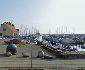
Dragør Harbour (Dragør Havnen) is a pretty small town harbour which is mainly used by private citizens. It is believed that the Dutch built the harbour around year 1600. There were many Dutch and Germans living in Dragør around that time.
Point 10: Dragør Museum

Dragør Museum is dedicated to telling the story of the colourful history of the town. The building was originally built as a storehouse in 1600, and was later used as the town’s city hall. The exhibition includes an antiquity collection, ship models, Dutch flagstones and several interesting curious artefacts brought home by the skippers from Dragør over the years. In the harbour lies the ship Elisabeth K571 which is technically part of the museum. During the Second World War the ship saved 600 Jews by sailing them to safety in Sweden. The Museum is open from May 1st to September 30th.
Point 11: Pilot House (Lodshuset)

The Pilot House (Lodshuset) is the first Pilot House in Denmark built in 1684. There’s a observation tower on the roof of the house. Now the Pilot House is the Danish Pilotage Museum. The museum is situated by the harbour front in Dragør and gives an insight into the life of the sea pilots of Øresund. Sea piloting as a profession in Denmark actually began in Dragør in 1684 when 6 seamen were granted royal privilege to pilot ships through Øresund.
The building itself was in active use as a pilot station from 1823 until 2006 and shows you the working conditions of sea pilots and boat crew.
Finish walk – Cafe Espersen
Questions for a sustainable future
- Where are there opportunties for Dragør to be more sustainable?
- What is already happening in Dragør around eco awareness? Recycling? Water and energy efficiency? Waste Management? Efficienct Transport? Reducing Waste?
- What are some of the vulnerabilities faced by the Dragør community in the future?
- How can you contribute to creating a more eco aware community in Dragor and beyond?
- The ocean has played a significant role in Dragør’s history – what will it’s role be in the future?
- What is your vision for the future of Dragør and Copenhagen?
- How is that vision connected to global awareness?
References
Dragør Fort – http://dragorfort.dk (accessed 12 September 2014)
Copenhagen – Tourist Attractions www.danishnet.com (accessed 12 September 2014)
Dragør Lokalarkiv Aktuelt http://www.dragoer.dk/page919.aspx (accessed 20 September 2014)

Leave a comment